


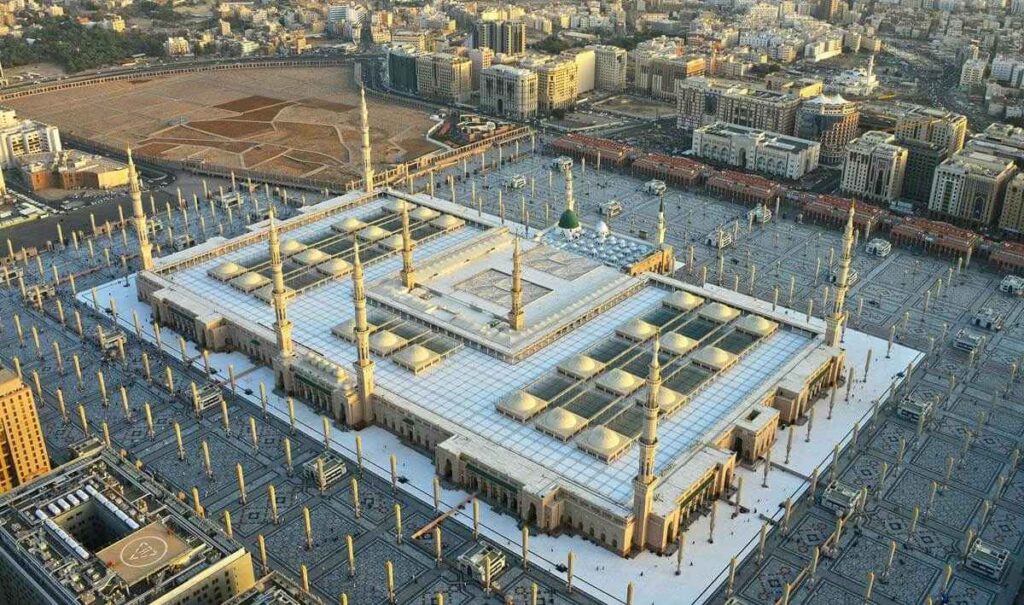
Masjid al-Nabawi in Madinah is one of the largest and most spiritually significant mosques in the world. Due to its vast size, multiple expansions, and millions of visitors throughout the year, understanding a Masjid al Nabawi map is essential for every pilgrim and visitor. A well-used map helps you locate gates, prayer areas, Rawdah al-Sharifah, women’s entrances, accessibility services, and surrounding roads without confusion or unnecessary walking.
This guide explains how to read and use Masjid al-Nabawi maps correctly, based on real layout structures and official information, so your visit remains focused on worship rather than navigation.
Why Using a Masjid Al Nabawi Map Is Essential
Masjid an-Nabawi covers a massive area that includes the original mosque, multiple Saudi expansions, open courtyards, underground facilities, and roof prayer zones. During peak Umrah seasons, entry points, Rawdah access, and visitation routes are strictly managed. A detailed map allows you to understand where you are standing, which gate is closest to your destination, and how to exit safely after prayers.
Without a map, many visitors unintentionally walk long distances, enter incorrect gates, or miss their scheduled Rawdah time.
Types of Masjid Al Nabawi Maps Available
Official Interactive Maps
The most reliable maps are the official interactive maps provided by the General Authority for the Care of the Two Holy Mosques. These digital maps show gates, internal sections, service icons, elevators, wheelchair routes, and surrounding streets. They are especially useful during crowded periods because they reflect real-world navigation logic.
Downloadable PDF Maps
Official PDF maps in English and Arabic are widely used by pilgrims. These maps clearly label gate numbers, courtyards, Rawdah location, women’s sections, toilets, parking areas, Zamzam water points, and health centers. Many pilgrims download these maps to their phones before leaving their hotels.
Google Maps for External Navigation
Google Maps is useful for reaching Masjid al-Nabawi from your hotel or parking area. While it does not show interior prayer layouts, it accurately displays surrounding roads such as King Fahd Road, King Abdulaziz Road, and As-Salam Road, which are marked on official mosque maps for orientation.
Understanding Orientation Inside Masjid al-Nabawi
Qiblah Side and Mihrab Location
On every Masjid al Nabawi map, the Qiblah side is the southern side. This is where the mihrab and imam stand during prayer. Most maps clearly mark “Qiblah” to help visitors align themselves correctly, especially when entering from northern or eastern courtyards.
Surrounding Roads and Courtyards
Maps also label major roads surrounding the mosque. These references help you choose the nearest gate from your hotel or drop-off point and remember your exit location after salah.
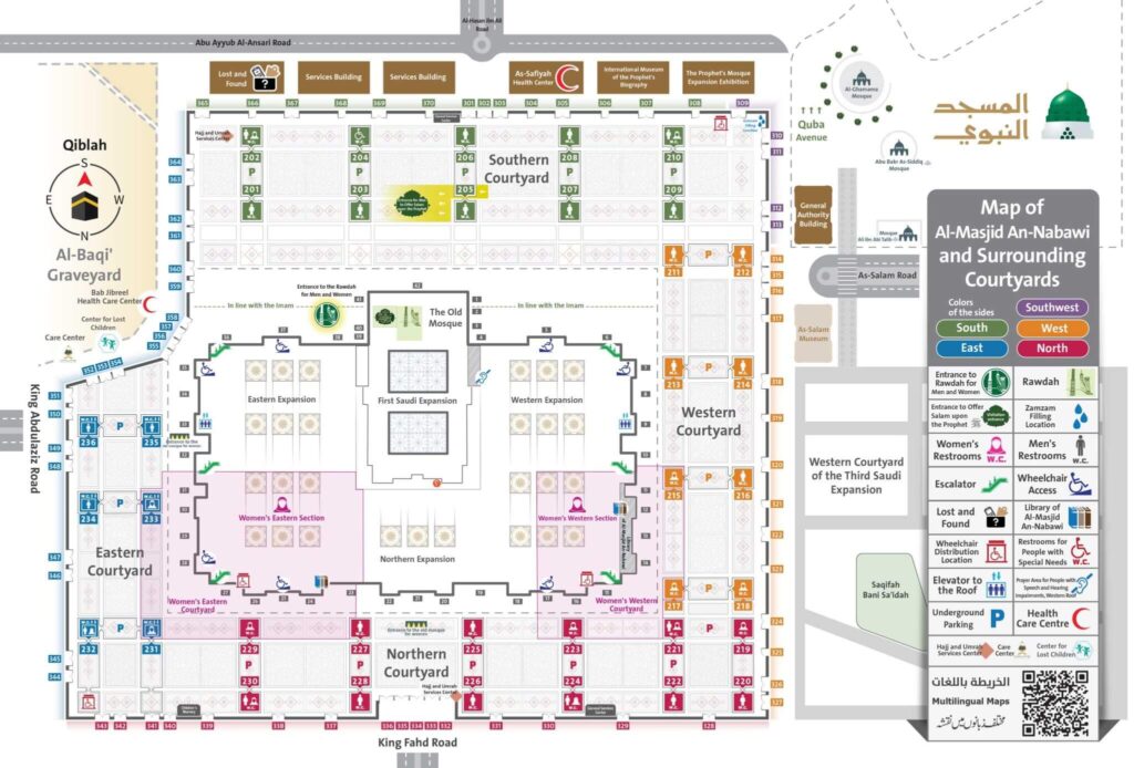
Key Areas Marked on Masjid Al Nabawi Maps
Rawdah al-Sharifah
Rawdah al-Sharifah is the sacred area between the Prophet’s ﷺ minbar and his blessed chamber. On maps, Rawdah is clearly marked and separated from general prayer areas. Entry is controlled and assigned through specific gates for men and women, which are always highlighted on official layouts.
The Green Dome and Prophet’s Chamber
The Green Dome appears on maps at the south-eastern side of the mosque. While visitors cannot enter the chamber itself, maps guide worshippers to the correct visitation pathway to offer salam upon the Prophet Muhammad ﷺ.
Old Mosque and Expansions
Maps distinguish between the Old Mosque area and later Saudi expansions to the north, east, and west. This helps visitors understand their position inside the complex and orient themselves during prayers.
Al-Baqi Cemetery Access
Al-Baqi Cemetery is marked near the eastern side of Masjid al-Nabawi. Access points and walking routes are indicated on detailed maps, especially for morning visitation times.
Gates of Masjid al-Nabawi Explained
Masjid al-Nabawi has hundreds of numbered gates, many of which also have historical names. Commonly referenced gates on maps include Bab al-Salam, Bab Jibreel, Bab al-Hijrah, and Bab al-Nisa’. Each gate number corresponds to a precise courtyard location, allowing visitors to plan their entry and exit efficiently.
Special gates are designated for Rawdah access and for offering salam. These are clearly labeled on official maps and differ for men and women.
Women’s Prayer Areas and Entrances
Women’s prayer areas are clearly marked on Masjid al Nabawi maps, primarily located on the eastern and northern sides depending on crowd management. Dedicated entrances for women are labeled, and Rawdah access routes for women are strictly separated and scheduled. Using a correct map prevents confusion and ensures smooth entry at assigned times.
Accessibility, Wheelchairs, and Visitor Services
Official maps use universal icons to show wheelchair distribution points, ramps, elevators to roof prayer areas, special-needs toilets, health centers, Zamzam water stations, and lost-children centers. Elderly pilgrims and those with mobility challenges benefit greatly from studying these routes in advance.
Best Times to Visit Masjid Nabawi to Avoid Crowds
Maps help you plan visits during quieter periods, typically after Fajr, late morning before Dhuhr, or late night after Isha. Rawdah visitation times are regulated, and identifying the correct gate beforehand reduces waiting time and stress.
How to Use the Masjid Al Nabawi Map Practically
Before leaving your hotel, identify the nearest main road and select a gate close to it. Memorize that gate number as your meeting point after prayer. If visiting Rawdah or offering salam, follow only the routes marked on the map, as crowd control pathways change regularly.
Transportation Tips for Visiting Masjid al-Nabawi
Comfortable and reliable transportation plays a major role in a peaceful Madinah visit. Many Umrah and ziyarat travelers prefer private taxis to avoid long walks and parking difficulties. A dedicated Umrah taxi service allows you to be dropped close to your preferred gate, return safely after prayer, and travel conveniently to ziyarat locations such as Quba Mosque, Uhud, and Al-Baqi.
For visitors seeking Umrah taxi services, Madinah hotel transfers, and ziyarat transportation, professional local transport providers ensure timely pickups, knowledgeable drivers, and routes aligned with Masjid al-Nabawi access points—making your spiritual journey smoother and stress-free.
Conclusion
A Masjid al Nabawi map is more than a navigation tool; it is a guide that enhances your spiritual focus by removing uncertainty and confusion. Understanding gates, Rawdah access, women’s sections, services, and surrounding roads allows you to move confidently within one of Islam’s most sacred spaces. By combining proper map usage with reliable transportation and thoughtful planning, your visit to Masjid al-Nabawi becomes peaceful, organized, and deeply rewarding.

Zeeshan is a professional driver and tour guide who has been living and driving in Saudi Arabia for the past 5 years. With deep knowledge of the roads, landmarks, and Ziyarat locations across Makkah, Madinah, Jeddah, and Taif, he helps pilgrims and travelers enjoy safe, smooth, and well-organized journeys. His experience in Umrah transport, city tours, and airport transfers makes him a trusted expert for visitors exploring Saudi Arabia.